Travel Life and Stuff

Explore My Adventures and Life Moments
Welcome
to Travel, Life and Stuff
Welcome to my journey! Join me as we explore the incredible places I've visited and the fascinating people I've met along the way. Through photos, interviews and captivating stories, we'll uncover the uniqueness of life together. This website will continuously evolve, showcasing road trips, nature, and the beautiful narratives that inspire us, through my eyes and lens.
Through the Silence of the Northern Cape
Since returning to Cape Town in 2000, there has been one journey I have consistently looked forward to more than any other.
By most standards, it is not an epic road trip stretching across continents, nor is it considered particularly adventurous. Yet for me, this route through the Northern Cape offers something increasingly rare — silence, solitude, and a profound sense of reflection.
There is little to no radio reception along much of the route, but over time I came to realise that sound was unnecessary. The landscape itself speaks in its own quiet language. In the vast emptiness of the Karoo, beauty reveals itself not through abundance, but through simplicity and stillness.
By the second day of the journey, I would usually arrive in the small town of Nieuwoudtville, home to just over 2,000 residents. Known internationally as the “Bulb Capital of the World,” the town is famous for its remarkable wildflower displays and thriving bulb export industry.
Travelling approximately six kilometres northeast of the town, a roadside sign points toward a waterfall — something that seems entirely out of place in this semi-desert landscape. Curiosity always got the better of me.
After a brief conversation with a visibly bored attendant, I set off on foot through knee-high Karoo shrubland. Then, quite unexpectedly, the landscape opened before me. There, hidden among the rugged terrain, was the Nieuwoudtville Waterfall — dramatic, isolated, and entirely unforgettable.

A satelite image of Nieuwoudt Waterfall.
Photo Credit: Google Maps
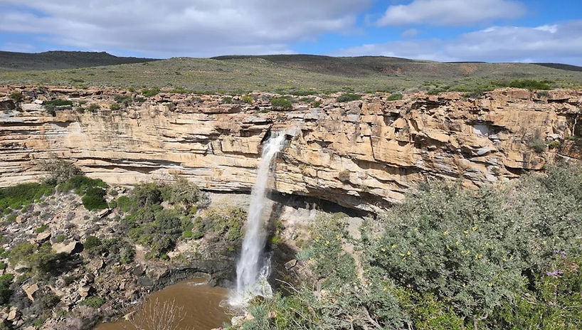
A photo from the ground across Nieuwoudt Waterfall.
Photo Credit: Leon du Toit
The journey, however, was far from over.
The roads beyond are quiet, with only the occasional oncoming vehicle breaking the stillness. The veld undoubtedly shelters snakes, scorpions, and countless other desert creatures, but stopping to investigate them never formed part of my plans. The destination always called louder than the dangers along the way.
Roughly 40 kilometres further on lies one of my favourite places on the route. I would always stop there, standing silently beside an old fence despite the harsh summer heat that often exceeds 32°C. Time seemed irrelevant in those moments.
Places like these awaken the imagination. Who built the structures that now stand weathered and forgotten? Who lived there? Were they happy? Where are their descendants today? Could I have survived in such isolation and made a life here? Even now, I remain uncertain.


A photo from the ground across Nieuwoudt Waterfall.
Photo Credit: Leon du Toit
Continuing onward toward Loeriesfontein, the landscape becomes even more remote. The origin of the town’s name remains uncertain, particularly since the Loerie bird is not native to the area. One popular theory suggests the name originated from a travelling salesman named Lurie who frequented the region.
Loeriesfontein is also home to one of the most unusual attractions in South Africa — a windmill museum that celebrates the mechanical lifeline of the arid Karoo.

The windmill museum in Loeriesfontein
Photo credit: Google

A satelite image of Nieuwoudt Waterfall.
Photo Credit: Google Maps
From there, travellers face a choice.
The direct route to Brandvlei spans approximately 120 kilometres along rough, unpaved roads scattered with shale rock and hidden hazards. Vehicle breakdowns are a genuine concern, and encountering another traveller can be rare. In such isolation, assistance may take hours — even days — to arrive.
The safer alternative involves a lengthy detour via Nieuwoudtville and Calvinia, extending the journey to nearly 300 kilometres on tarred roads.
I almost always chose the shorter route.
There is something deeply rewarding about committing to uncertainty and embracing the untamed road ahead. Despite the risks, I was fortunate enough never to suffer a breakdown, puncture, or even thirst along that route.
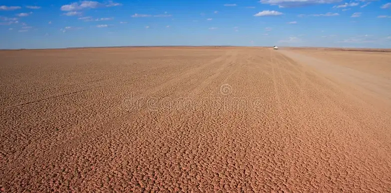
One landmark always stayed with me: the farm Verdwaalvlei, whose name translates to “Lost Marsh” or “Lost Wetland.” In a landscape defined by dryness, the irony is unmistakable. The terrain stretches endlessly beneath open skies, barren yet strangely captivating.
The question remains…………did the driver of this car get lost (verdwaal)?

A photo from the ground across Nieuwoudt Waterfall.
Photo Credit: Leon du Toit
This region is renowned for sheep farming and vast salt pans, most notably Verneukpan — an immense dry salt pan measuring approximately 57 kilometres long and 11 kilometres wide. Verneukpan is famous for its surreal mirages, profound silence, and historical significance as the site where Sir Malcolm Campbell attempted a land-speed record in the Bluebird during the 1930s.

A photo from the ground across Nieuwoudt Waterfall.
Photo Credit: Leon du Toit
My own journey was considerably slower.
I broke no speed records on these roads, but over four days I discovered something far more valuable: quiet joy, uninterrupted reflection, and a renewed appreciation for the vast and often overlooked beauty of the Northern Cape.
Thank you for accompanying me on the journey.


A photo from the ground across Nieuwoudt Waterfall.
Photo Credit: Leon du Toit
A photo from the ground across Nieuwoudt Waterfall.
Photo Credit: Leon du Toit